A summer downpour can turn a beautiful Greenville Country Club backyard into a fast-moving stream. If you are buying or selling near the course, managing stormwater is about more than puddles. It affects property value, maintenance, and peace of mind. In this guide, you will learn how GCC-area lots drain, how to spot risks, practical fixes you can use, and which rules apply so you can move forward with confidence. Let’s dive in.
Know your jurisdiction and rules
Before you plan any project, confirm whether your lot sits inside the City of Greenville or in unincorporated Greenville County. The City and County run separate stormwater programs and permitting. Start with the County’s Stormwater Management page for county parcels or the City’s Stormwater Management page for city parcels to verify who regulates your site and how reviews work. South Carolina DHEC also administers statewide NPDES stormwater permits for construction, which can apply in addition to local rules.
- County guidance and permits: Greenville County Stormwater Management
- City guidance and permits: City of Greenville Stormwater Management
- State thresholds and permits: SCDHEC Stormwater Overview
Flood maps and insurance context
Check whether a property is in a FEMA Special Flood Hazard Area using the FEMA Map Service Center. The County’s floodplain administration can help with property-specific questions and Letters of Map Amendment. Greenville County participates in FEMA’s Community Rating System, and the County website has referenced a 15% NFIP discount in the past. Always confirm the current discount and map status with the County before closing.
- Floodplain help: Greenville County Floodplain Administration
- Why to look beyond maps: some analyses note FEMA maps can miss localized flash flooding, especially along small channels. See a local explainer on limitations of flood maps for flash-flood risk.
Spot common GCC lot risks
GCC-area properties often include rolling terrain, mature trees, and nearby course water features. Walk the lot after a storm and look for how water moves.
- Slopes and grades. Steep rear or side slopes can concentrate runoff and cause erosion. Homes sited downslope from driveways or neighboring yards may see water pushed toward foundations.
- Streams and ponds. Even outside mapped flood zones, being near a channel raises flash-flood and bank-erosion exposure. Expect buffers or setbacks to apply near water features.
- Soil infiltration. Heavy clay or compacted fill reduces infiltration and increases ponding. A simple percolation check helps size rain gardens or infiltration features. Clemson Extension offers a virtual rain garden guide and soil basics.
- Impervious areas. Larger roofs, driveways, and patios increase peak runoff. Downspouts and driveway drainage deserve extra attention.
- Easements and covenants. Recorded drainage easements, shared swales, and HOA or club rules can limit what you can change. Review the plat, deed, and GCC-related covenants before altering grades.
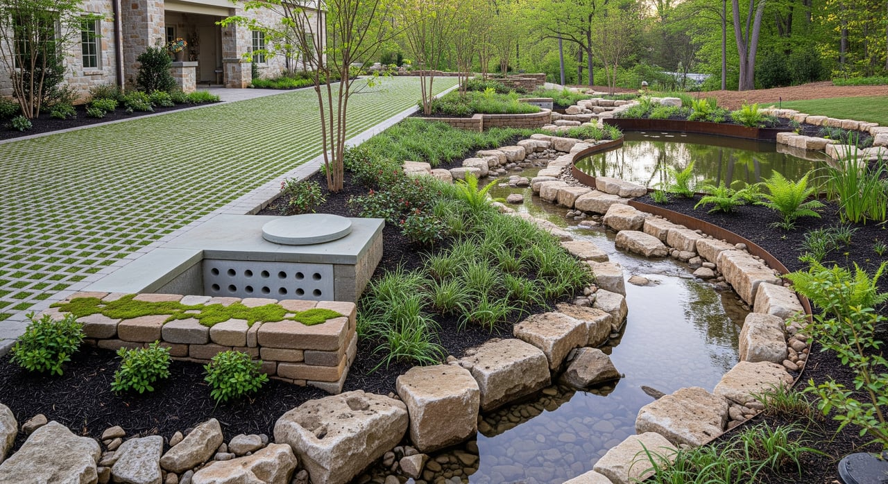
Practical on-lot fixes that work
Small, well-placed measures go a long way on residential lots. Start with low-impact steps, then consider engineered options if needed.
Vegetated options
- Rain gardens and bioretention. Shallow, planted depressions capture and infiltrate roof and yard runoff. Place at least 10 feet from foundations and confirm infiltration rate. Clemson provides South Carolina-tailored how-tos and plant lists through the Carolina Rain Garden Initiative.
- Buffer strips near water. Native plant buffers along streams and ponds slow flow, filter sediment, and help stabilize banks.
- Preserve trees. Mature canopy intercepts rainfall and strengthens soils. Limit unnecessary clearing during renovations.
Conveyance and subsurface measures
- Rain barrels or cisterns. Capturing roof runoff for irrigation reduces peak flow. Clemson includes rainwater-harvesting guidance within its rain garden resources.
- French drains and shallow infiltration trenches. Subsurface gravel and perforated pipe can intercept sheet flow where surface grading is tight. Proper slope, filter fabric, and cleanouts matter for longevity.
- Permeable pavers. Driveway or patio systems that let water pass through can cut runoff when paired with the right stone base and routine maintenance.
Structural or engineered options
- Dry wells and infiltration basins. Deeper storage that slowly soaks into the soil. Site suitability depends on infiltration rate and groundwater depth.
- Small detention or retention features. Where downstream capacity is limited, on-lot storage can reduce peak flows. Expect permitting and defined maintenance if there is a discharge.
- Regrading and swales. Create positive drainage away from foundations and use shallow grassed swales to direct water to a safe outlet. Larger grading can require permits.
During construction or major landscaping
If you plan substantial work, erosion control is not optional. Silt fence, stabilized construction entrances, temporary seeding, and mulching are standard practices and often required. Review DHEC’s thresholds for land disturbance and coordinate with the City or County early. See SCDHEC’s stormwater overview for permit triggers.
Permits and maintenance 101
- Permit triggers. Disturbing 1 acre or more typically requires state NPDES coverage and local plan review. Sub-acre projects near streams or in sensitive spots can still draw local review, so ask the permitting office before you begin.
- Floodplain lots. If a property is in the floodplain, contact the local floodplain manager for the base flood elevation and any required freeboard. The County provides floodplain guidance and contacts.
- Long-term upkeep. Many on-site stormwater features are private, not public. Greenville County’s code assigns ongoing maintenance to the owner or HOA for private BMPs and includes inspection and enforcement provisions. Review recorded documents and the County’s code sections on maintenance so you know who is responsible.
A simple action plan for buyers and sellers
- Confirm jurisdiction. Verify City versus County first, then follow the correct permitting path.
- Check flood risk. Pull the current FEMA map panel and ask the local floodplain administrator for property-specific guidance.
- Walk the site after rain. Note any ponding, erosion, or downspout splashback toward the foundation.
- Start with low-impact fixes. Downspout extensions to vegetated areas, a rain barrel, or a small rain garden can make a quick difference. The EPA’s homeowner guide to rain gardens is a practical reference.
- Plan larger projects early. Pools, additions, or major regrading can trigger permits. Coordinate with the City or County and a qualified professional before you break ground.
- Clarify maintenance. Ask in writing who maintains any swales, ponds, or private drains and how that is funded.
If you want a property-by-property take on drainage risks before you list or write an offer, reach out. As a local advisor, I can help you coordinate the right due diligence and position your next move with clarity. Connect with Ashley Swann to get started.
FAQs
How do I check if a Greenville Country Club lot is in a FEMA flood zone?
- Search the address in the FEMA Map Service Center, then confirm the finding with the City or County floodplain administrator for an official determination.
What permits could a new pool or patio trigger near GCC?
- Significant impervious area or grading can require local plan review, and land disturbance of 1 acre or more typically needs state NPDES coverage through SCDHEC.
How much rain does Greenville get and why does it matter?
- Greenville County averages roughly 45 to 51 inches of annual precipitation, and intense summer storms can overwhelm poor drainage, so sizing on-lot controls to local rainfall patterns matters. See the South Carolina State Climate Office.
Are rain gardens allowed and where can I learn how to build one?
- Small rain gardens are common homeowner projects when sited correctly and outside easements; Clemson Extension’s Carolina Rain Garden Initiative provides South Carolina-specific design steps and plant lists.
Who maintains drainage swales or ponds serving my lot?
- Recorded plats, deeds, and HOA or club covenants usually assign maintenance, and County code places long-term BMP upkeep on owners or HOAs. Review documents and the County’s maintenance provisions before closing.
Do FEMA maps show flash-flooding along small streams near the course?
- FEMA maps focus on larger, modeled hazards and can miss localized flash-flood risk, so check topography and site drainage in addition to map status and review this local note on map limitations for flash flooding.